
How Acreage Verification Can Reduce Investor Risk
Turning conflicting land records into practical risk mitigation for farmland transactions and management.
Executive Summary
In agricultural real estate, acreage is the foundation of nearly every financial and operational assumption in a transaction. Purchase price, lender collateral analysis, lease economics, irrigation coverage, productivity estimates, and post-closing management plans all depend on one basic question: how many acres are actually being bought, financed, leased, or operated? And they often are not the same number.
That question is rarely as simple as it appears. Tax assessor records, irrigation district records, deeds, legal descriptions, surveys, FSA maps, GIS layers, broker materials, and legacy ownership records often report different acreage figures. One source may show total deeded acres, another may show taxable acres, another may reflect FSA cropland, and another may include nonproductive areas such as ditches, roads, wooded edges, waterways, ponds, wetlands, turn rows, or excluded parcels. In most cases, the issue is not that anyone intended to misstate the asset; rather, different records were created for different purposes, at different points in time, using different definitions of acreage. Without a disciplined due diligence process, those differences can remain hidden until a purchase closing, causing confusion, suspicion, and delays.
Challenge
We have seen these discrepancies surface across multiple transaction scenarios: acquisitions where the buyer was relying on marketed acreage, dispositions where the seller needed defensible acreage verification before going to market, lease negotiations where rent was being calculated on an inaccurate farmable-acre base, and closing processes where counsel, lenders, or title teams needed a clean acreage reconciliation before documents could be finalized.
Acreage discrepancies can affect valuation, price-per-acre calculations, lender underwriting, title review, allocation of improvements, managerial decisions, per-acre yield calculations, lease assumptions, and input budgets. If discovered late, they can delay closing, force rushed negotiations, create mistrust between the parties, result in a client paying for acres that are not economically productive, or cause a transaction to fall apart.
The recurring unknowns include:
• Whether the contracted acreage matched the legal description and parcel boundaries
• Whether tillable, irrigated, non-tillable, wooded, waste, conservation, encumbered, or excluded acres were properly classified
• Whether the client was paying for acres that didn’t exist or that were not as represented
• Whether historic management practices, boundary assumptions, or leasing agreements had created inaccurate beliefs about the asset
In some cases, what the parties believed to be true about the property was not supported by the facts discovered during due diligence.
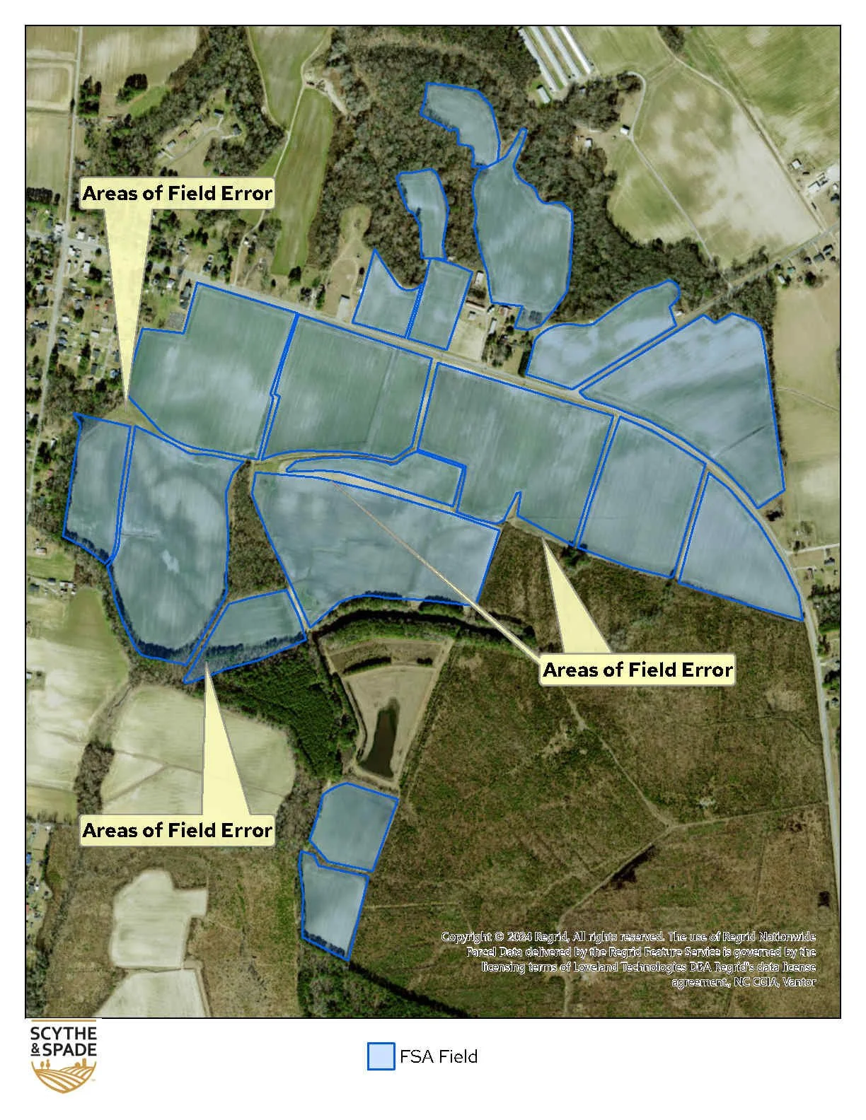
In one such transaction, the LOI was negotiated based on FSA acres, which is a common method to use as a starting point in negotiation and should always require further refinement through detailed verification. During the process of due diligence, our team quickly discovered that the FSA maps were outdated and inaccurate. Fields had been reconfigured and no longer match the represented acres, there were fields that encroached on wetlands that did not qualify as prior converted, and there were fields that were classified as irrigated that did not have sufficient water supply.
In another instance, a buyer came back a few days prior to closing with their own field acre calculations. There were no major differences between the buyer and seller’s field boundaries. However, each field was just slightly off from the other. Death by a thousand cuts. The acreage calculations were within 0.5%. But 0.5% on approximately 4,000 acres is about 20 acres. Assuming a $8,500/acre value, that’s a $170,000 discrepancy. Having an established source of truth for acres up front and a clear contract saved our client from a last-minute attempt to retrade the transaction.
Solution
Find and solve the acreage discrepancies before it becomes a problem. Treat acreage verification as a risk-control exercise, not just a mapping task. The objective is to give the client, counsel, lender, broker, and internal decision-makers a clearer, supportable acreage framework of what is being transferred and how the acreage should be used for pricing, diligence, closing documentation, and post-closing management.
In the first scenario above, our team worked together to create clarity for all parties. The discovery early in the process gave the buyer the opportunity to address the issues while negotiating the contract and to work with the seller on a solution that worked for both parties. Our GIS team used proprietary FarmBase™ mapping and analysis system to map and calculate the exact irrigated acreage. By overlaying historical imagery with wetlands, analysts confirmed that wetland areas were being included in the seller’s tillable acre calculations, identified field boundary discrepancies early in the process. Our analysts reconciled available acreage sources, reviewed parcel and boundary data, and compared legal descriptions against GIS and assessor records; distinguishing economically meaningful acres, including irrigated and nonirrigated tillable acres, and conservation acres from total acres. Our regional director provided a structured analysis from the historical appraisal data, recent local sales data, and FarmBase™ analysis provided by our team to position our client to negotiate the contract from a place of authority.
In the second scenario, we were able to anchor our tillable (irrigated and non-irrigated) acreage calculations to a single source of truth prior to going to market. We then worked with the seller’s counsel to structure the contract using clear definitions of the acres to which value was attributed to and provided supporting exhibits from our pre-market due diligence work. The relationships between your trusted advisors are a vital part of any transaction.
There is great value in converting conflicting sources into a structured framework. Instead of leaving the client with competing acreage figures, our team clarified what acres were included, what acres had economic value, what acres were uncertain or excluded, and how those distinctions should affect price, diligence, financing, and post-closing management. In lease and management contexts, verified acreage helps align rent, input budgets, yield assumptions, and management responsibilities with the land actually being farmed.
Takeaways
Verifying acres ahead of time saved clients time, money, and stress by eliminating uncertainty. Across these scenarios, acreage verification helped identify discrepancies before they became settlement disputes, supported price adjustments where appropriate, clarified lender and title questions, and gave decision-makers a clean factual basis for closing.
The broader conclusion is that verified acreage protects not only the transaction, but long-term value. For agricultural assets, “acres” are not just a number in a purchase agreement. They are the basis for valuation, financing, income assumptions, operating plans, lease economics, and long-term asset performance. When acreage is wrong or unclear, every downstream decision is exposed to dispute. When acreage is confirmed early, clients are better positioned to evaluate risk, negotiate faithfully and thoughtfully, and execute with greater clarity.