Trust but Verify: Ensuring Accuracy in Third-Party Survey Work
Executive Summary
Agricultural real estate investment relies heavily on accurate data to guide land acquisition and dispositions, crop planning, risk assessment, and long-term portfolio strategies. Land Surveys (Boundary to ALTA) play an essential role in real estate transactions. Having a trusted surveyor is invaluable to the success of a project. However, relying solely on vendor-provided findings (of any type) without verification introduces risks and potential liability that can affect asset valuation, leases, title work, deeds, encroachments, and investor confidence. All of which can be expensive to correct and/or may lower property resale value. Today we’re going to discuss the value of thoroughly reviewing surveys as an example of why applying a 'trust but verify' framework to is vital to a successful transaction. Do the due diligence that’s due.
1. Introduction
Surveys inform decisions such as valuation and risk models that carry long-term financial implications. Easement boundaries, less & except boundaries, deeded reservations, acres, and as-surveyed legal descriptions are data points that inform these decisions. Accuracy is crucial.
2. Why Review Third-Party Survey Work?
Even trusted survey firms can make mistakes and errors which can have very real and costly consequences. Or they could miss previous errors that might be decades old, such as incorrect legal descriptions in title insurance policies, deeds, leases, and mis-represented easements. Surveyors are after all, only human.
This can lead to stressful transactions, drawn out closings, increased pre- and post-closing legal fees, and potentially even litigation. Reviewing surveys in detail is therefore not optional; it is essential governance practice. A rigorous review is tedious but protects investors, operators, and stakeholders by ensuring that critical decisions are made using verified, reliable data. Additionally, having established relationships with trusted vendors/surveyors in each region is invaluable, greatly reducing the amount of review and oversite needed.
2.1 Common Sources of Error in Surveys
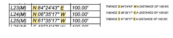
A previous large, complex transaction we managed for a client included surveys of ten different tracts and two divisions of land plats, spread across two counties. It was in a region where we couldn’t pull from our established pool of trusted, quality surveyors. In one of these surveys alone, we identified 23 discrepancies between the survey calls (the bearing and distances shown on each line of the survey) and the as-surveyed legal description. This was in addition to missing data, missing easements, approximate/non-finalized boundary lines, incorrect number sheets, and more on what the surveyor had deemed as final surveys. Though most of the discrepancies in the calls didn’t create a substantial difference, each one makes us ask “why is there a discrepancy?” This not only costs time and money to flush out, but it also leads to the erosion of trust and confidence in the vendor. In the project examples below, our team completed a structured, geospatial review of each survey and worked with the vendor/surveyor to have each issue corrected within a very tight closing timeline.
Conflicting As-Surveyed Call Direction and Measured Survey Call Direction: Note the direction of the surveyed line call on the left vs the as-surveyed legal description on the right.
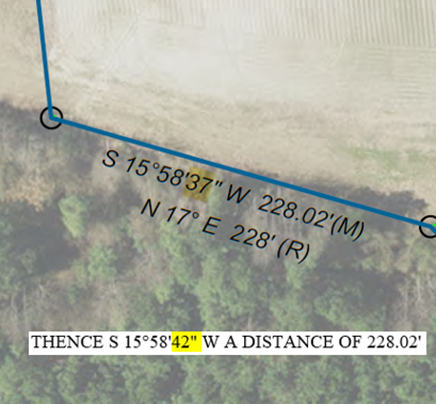
Conflicting Call Directions and Measurements: This example below shows a difference in direction, 37” vs 42”, which is a 0.0664” difference in location over 228.02’. A minute difference that is well within the margin of error but still a discrepancy that costs time and money to flush out.
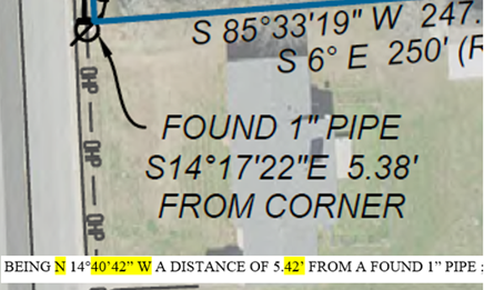
This second example shows a difference in direction, 40’ 42” vs 17’ 22”, and distance, 5.38’ vs 5.42’. Again, this turned out to be a small difference on the ground, but each discrepancy must be examined, which takes time, adds cost, and slows down the transaction.
Missing Calls: No direction or distance between two points in the example below. Dashed/”approximate boundary line” on final survey.
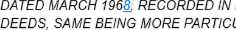
Incomplete As-Surveyed Legal Descriptions: Incomplete sentences and dates shown in the example below.

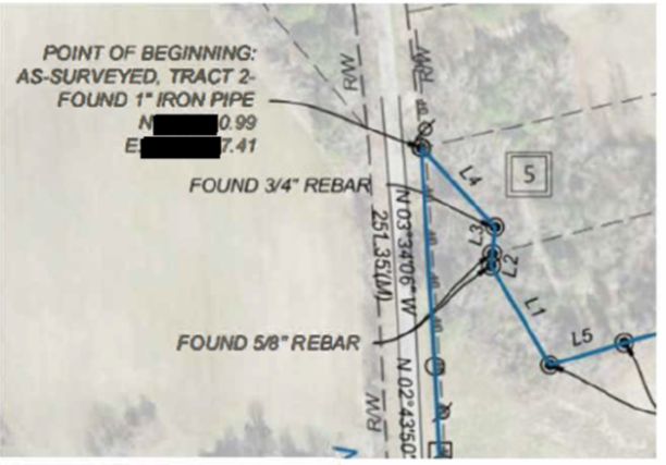
As-Surveyed Legal Description and Survey POB (Point of Beginning) and Closure Discrepancies: In the example below, N:XXX.XX1.06’ E:X,XXX,XXX.32’ vs N:XXX,XX0.99’ EX,XXX,XXX.41.
3. What 'Trust but Verify' Looks Like
A structured, geospatial review process includes:
Logistical Review: When do the surveys need to be filed, who needs to file them, do the attorneys and title company need the filing details to complete title and/or deeds? Who needs to review and approve final versions? What is the timeline for each step? In what format, format, scale, and product (ie mylar vs paper) do the surveys needs to be delivered?
Technical Review: A qualified GIS team to review the legal description against the survey and the as-surveyed legal description. Do the calls and distances match? Do they match what’s mapped? Do they match the legal description in the title policy? Are the acres, easements, and access essentially what was anticipated and expected in pre-due diligence work?
Detailed Review: A detailed review of the survey title, sheet numbering, tract numbering, APNs, what office is the survey being certified to, and does the survey meet county filing requirements?
Feedback Loop: A structured feedback loop between the survey team and the advisory firm is vital. How are errors communicated, what is the turnaround time for revisions, and who is accountable for ensuring the final version is accurate, on time, exactly as promised?
4. Best Practices for Agricultural Investment Advisory Firms
- Provide vendors with standardized RFPs and require a clear statement of work that clearly defines expectations for timelines, communications, and the review and revision process.
- Require transparent communication and regular project updates.
- Proper timelines allow red flags to be identified early, giving adequate time to mitigate issues without delaying closing.
- Maintain internal expertise capable of validating survey findings and challenging errors or relationships with reliable external regional expertise.
5. Conclusion
Surveys are an invaluable component of due diligence in understanding property rights, boundaries, and liabilities. However, investors should not rely solely on fractional multi-vendor expertise. A disciplined 'trust but verify' approach by your trusted advisory firm ensures data integrity, strengthens investment decisions, protects against costly errors, and reinforces credibility with stakeholders and capital partners and avoids testing or relying on your or their E & O professional liability insurance policies.