2023 Idaho Water Forecast as of March
by Matt Harrod
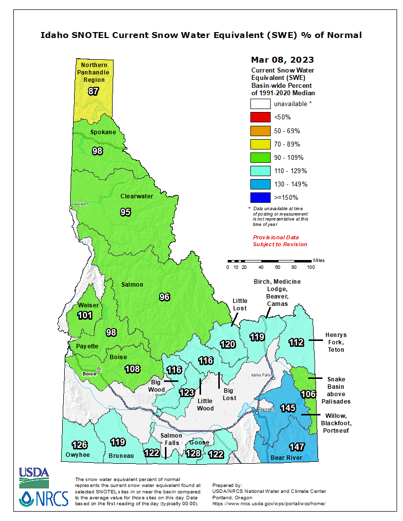
The outlook for Idaho surface water irrigation as of 3/1/23 is much improved along the Snake and Boise River systems for 2023 vs the previous two years due to above normal snowfall and precipitation in the current water year, however the central and panhandle regions of the state remain below normal.
According to the most recent USDA/NRCS Idaho Water Supply Outlook Report published 3/1/23, “February brought above normal precipitation to the Southern and Upper Snake River basins. We saw minor improvements in northern Idaho’s snowpack since last month, however, the below normal February precipitation in the Salmon, West Central, Wood and Lost basins decreased snowpack percentages compared to normal in the central part of the state. Despite lower than normal snowfall north of the Snake River Plain, the good news is that snowpack remains near to above normal south of the Panhandle. Water supply varies significantly across the state despite near to above normal snowpack conditions. Water supply will likely be limited for some Upper Snake River water users and Oakley Reservoir users unless the snowpack grows to well above normal and/or a rainy spring occurs. Water supply in the Boise River Basin looks very good this year. Water supply for Salmon Falls Reservoir users is on the cusp of being sufficient to meet irrigation demand; the streamflow forecasts currently predict sufficient water for this area. We are concerned about adequate water supply for Magic Reservoir water users due to low storage and the decrease in this area’s snowpack during February. However, water supply could be alleviated by the above normal snowpack in Camas Prairie this winter if more snowmelt is generated from this area than forecasted. We encourage watching the range of streamflow forecasts available for this area, especially if the forecasted storm system brings as much water as predicted. Water supply is predicted to be adequate in the Owyhee, Bear River, Little Wood, Big and Little Lost basins at report time”.
The dynamics described above can be seen in the “Snow Water Equivalent Map” (SWE) on the left measuring snowpack, and the “Water Year to Date Precipitation % of Normal” map on the right, measuring total precipitation accumulation including rain and snow. As can be seen, the SWE map on the left show’s a snowpack above average in the southern and eastern regions of the state which feed the Snake and Boise river systems ranging from 107% to 139% of normal, but the northern regions which drain north and west below average ranging from 86% - 96% of average. Water year precipitation percent of normal on the right maintains a similar but somewhat less promising pattern, with figures ranging from 92% - 131% of normal in the south and east but only 77% - 84% in the northern regions.

Current Reservoir Storage Accumulation
System-wide storage in the Upper Snake remains both below average and below last year’s volume at this time. Combined storage in the upper Snake River system is 70% of average (46% of capacity). In contrast, the Boise & Payette River Basins are 115% of average (59% of capacity). Combined with the 104% snowpack in the Boise system and 96% in the Payette, the outlook for irrigation in Western Idaho looks quite positive.
Upper Snake River Basin Actual Reservoir Storage as 3.1.22

Boise & Payette River Basins Actual Reservoir Storage as 3.1.22
